

On February 3, 2021*, Geospace Model Version 2.0, which is part of the University of Michigan’s Space Weather Modeling Framework, will commence operations in support of customers affected by geomagnetic disturbances. This model replaces version 1.5 which has been in operations since November 2017.
The Geospace Model (SWMF) is a coupled global magnetohydrodynamic (MHD) model of Earth’s Geospace environment that extends from near Earth’s surface to 32 Earth radii toward the Sun on the dayside and 120 Earth radii into Earth’s magnetotail on the nightside. The Geospace Model utilizes three components of the University of Michigan's Space Weather Modeling Framework (SWMF). The model components are a global MHD magnetosphere, the Rice Convection Model for the inner magnetosphere, and the Ridley Ionosphere Model. Model predictions include ground magnetic disturbances resulting from Geospace interactions with the solar wind. Such magnetic disturbances induce a geoelectric field that can drive currents (Geomagnetically Induced Currents or GICs) in large-scale electrical conductors, such as the power grid, and have the potential, during disturbed times, to damage such systems. Short-term advanced warning from the model provides forecasters and power grid operators with situational awareness about harmful currents and allows time to mitigate the problem and maintain the integrity of the electric power grid.
The most significant changes between version 1.5 and 2.0 are:
-
Increased resolution for solving the MHD equations in targeted regions of the grid, moving from ~ 1 million to 1.9 million grid cells
-
Improved auroral oval specification and more realistic representation of magnetospheric current systems
-
New tail composition settings to better represent current systems responsible for the Disturbance Storm Time index (Dst)
-
A new method for calculating a predicted-estimated Kp (global geomagnetic activity index) based on magnetic variations from the Geospace model processed by a Kp algorithm that is the same as the one SWPC uses for calculating Kp from ground-based magnetometer stations.
The Geospace model products available on SWPC website include:
-
Geospace Geomagnetic Activity Plot, which shows solar wind input to the model as well as predicted Kp and Dst compared to the observed values
-
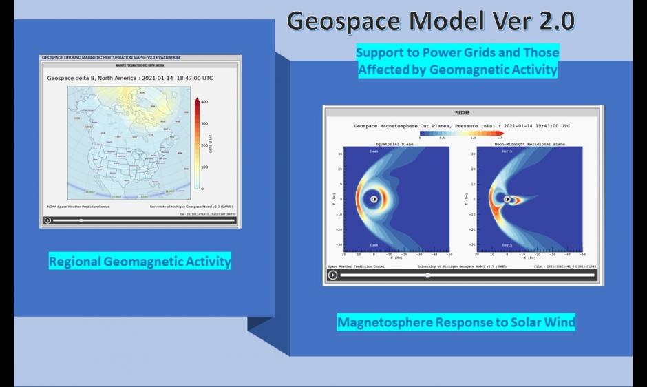
Geospace Ground Magnetic Perturbation Maps, which illustrate magnetic perturbations over North America, the polar regions, and the entire Earth
- Geospace Magnetosphere Movies, which show model density, velocity, and pressure in equatorial and meridian views in Earth’s magnetosphere
*Delayed from January 28 because IT changes are not permitted during severe weather in order to assure continuity of service.