

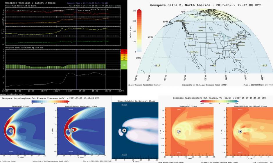
SWPC is pleased to announce that we have transitioned the entire set of Geospace model derived products from experimental to fully operational in order to better support forecasters and web-based customers. The suite of geomagnetic model products were declared fully operational on March 30, 2017, following an extensive review period and after implementing minor changes stemming from customer comments; and are now available under the "Models" section of our "Products and Data" tab. The Geospace model provides short-term guidance of the state of Earth's magnetosphere using real-time solar wind data and F10.7 cm flux (a solar EUV proxy) as inputs and provides regional guidance of geomagnetic activity for the first time. The geomagnetic model products include: The Geospace Geomagnetic Activity Plot - provides recent history of geomagnetic activity along with a short-term (15-45 minutes) prediction of upcoming activity. The Geospace Magnetosphere Movies - show graphical output for three different plasma parameters (velocity, density, and pressure). These graphic cut planes of the magnetosphere are useful for providing a large-scale, global context of geomagnetic activity in the near-Earth environment. The Geospace Ground Magnetic Perturbations Maps - display the gridded magnetic variations on a five-by-five degree global grid. These maps are useful for providing regional disturbance predictions that can be used by power grid operators to determine if disturbance are likely to have impacts at their general locations. Comments on these model products are always welcome via SWPC's feedback page.